An Introduction to Malibu Creek State Park

Located 35 miles from downtown Los Angeles and 7 miles from Malibu beach, MCSP in the Santa Monica Mountains, is set aside forever as a quiet refuge from the pressures of city life. Here visitors can enjoy a host of outdoor activities including picnicking, hiking, camping, bird and wild life watching, horseback riding, and fishing.


The Santa Monica Mountains stretch 46 miles from Griffith Park to Point Mugu. They form part of the Transverse Ranges of Southern California. They have been raised and tilted over millions of years by the earth’s geological forces. As the Santa Monica Mountains were slowly rising, Malibu Creek (after which the Park was named) was meandering across the land, cutting the scenic gorges and buttes through the 20 million year old volcanic mountains. The Mediterranean climate of this region, with cool wet winters and hot dry summers, create a “hot spot” for biodiversity, second only to the Rain Forest. Only four other places in the world (all on the west side of a continent and equal distance between equator and the pole) have a similar climate: the Mediterranean, central Chile (near Santiago), southwestern Australia (near Perth), and the Cape region of South Africa.

HISTORY OF THE PARK

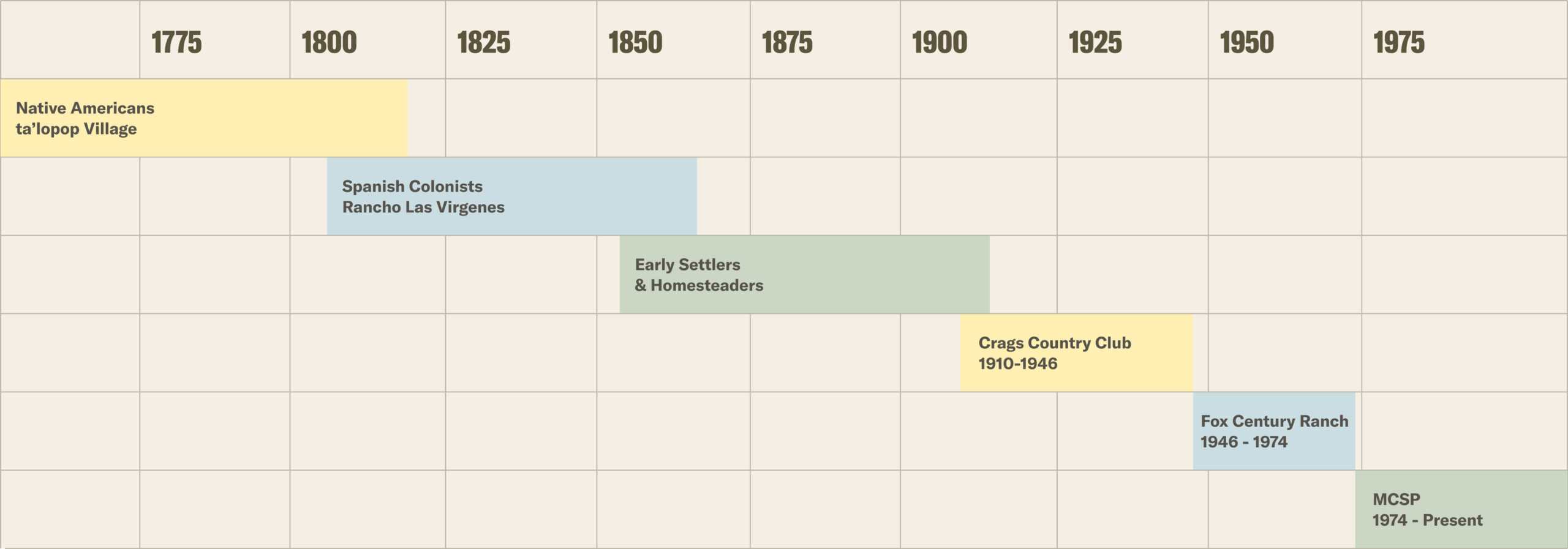
MCSP has a very rich history of Land use. From the original days of Chumash Native Americans, to the Spanish colonists, early settlers and homesteaders, followed by Crags Country Club and Fox Century Ranch, MCSP looks almost the same as it did in the 1800s with few changes.


Chumash Native Americans – prior to 9,000 years ago

Chumash Native Americans are the first known occupants of MCSP, where they found an abundance of natural foods – acorns, sage, seeds, fish, rabbits, and deer. For thousands of years they hunted, fished, and lived in villages of brush dwellings, such as the Chumash village of Talepop, located near the lower parking lot.


Early Settlers and Homesteaders – 1860s to 1910s

Homesteaders settled along the Malibu Creek Valley in the mid 1860’s with the passage of the Homestead Act in 1862. The Sepulveda Adobe, one of the Park’s significant points of interest, was constructed in 1863 on an early Spanish land grant. Chumash Indians helped make adobe bricks that were used by Pedro Sepulveda to build the home. A 4 year restoration project on this historic structure, located near North Grasslands trailhead, was completed in 2018. However before opening to the public, it was severely damaged by the Woolsey Fire in November of 2018.


Sepulveda Adobe before and after the Woolsey Fire

Crag’s Country Club – 1910s to 1940s

Harry D. Lombard and Edward D. Silent, country club founders, seeking a rural setting in which to enjoy the outdoors, together with a group of wealthy Pasadena businessmen, including William M. Garland, Sumner P. Hunt, John G. Mott, formed the prestigious Crags Country Club on 2,000 acres of land along Malibu Creek in 1909. The charter of this exclusive club limited membership to 100, with hefty annual dues of $1,000 (equivalent to $30,000 today). The Club ceased operation in 1936.

The Club constructed a 50 foot high dam, creating a lake that attracted waterfowl, and was stocked with trout, giving the club members a private hunting and fishing preserve. This dam and lake would later become Century Dam & Century Lake after the 20th Century Fox Studios bought the property. The 7,500 square foot Crags Country Club lodge was completed in 1910 near the lake and would serve as the center point for club operations and activities.


Crags Country Club Lodge

The lodge was demolished by 20th Century Fox Studios and today only the foundation of the lodge can be seen as you walk towards the Rock Pool area.


Crags country club lodge foundation & tennis court remains

During the active years of the Crags Country Club three private homes were built by club members. William Garland built a house, around 1910, which stood on the left side of Crags Road as it climbed uphill towards Century Lake. The building was removed in 1955 and today only the remaining foundation can be seen.


Part of the foundation of William Garland’s Home

The Hunt House is believed to have been built during the 1920’s by either Willis or Sumner Hunt (both were club member, but not related). This house was later used by the Fox Ranch caretaker and then became the MCSP Visitor Center (VC).


Hunt House ca. 1920 and Visitor Center today

The third home was the Mott Adobe, built by John G. Mott, on the Mott Road besides Malibu Creek. A fire destroyed most of the home in 1970.


Mott Adobe in 1930s

Today with only the dramatic stone fireplace remains standing and it is known as the Mott Adobe ruins (located on Mott road).

Remains of Mott Adobe

Fox Century Ranch – 1946 to 1974

Attracted by the dramatic scenery, 20th Century Fox bought the property in 1946 and renamed it Century Ranch; it was used as an outdoor film location for three decades. Famous movies and television shows such as Planet of The Apes, M*A*S*H, and Pleasantville were filmed at the Ranch.


Planet of the Apes set in 1968, near Century Lake

Pleasantville set location in 1998, now main trailhead parking lot

Mr. Blandings Dream House which was filmed in 1948, is still standing just north of the Camp Ground area, and is used as an office by California State Park.


Mr. Blandings Dream House, now California State Park Los Angeles District HQ

Deeper inside Malibu Creek State Park is the M*A*S*H site; a place where television history was made, where California became Korea, and where actors became doctors and nurses fighting to save lives.


M*A*S*H Cast on the set at MCSP, from “Three Magical Miles”

During the 1950s, Ronald Reagan bought a ranch in the hills of Malibu as a place to raise thoroughbred horses – named “Yearling Row Ranch” (hence Yearling Trail). When Reagan was elected Governor of California in 1966, he sold his ranch to 20th Century Fox. The only remaining structures were the barn and stables, which unfortunately burned during the recent Woolsey Fire.


Ronald and Nancy Reagan at their ranch in early 1950’s – from “Three Magical Miles”

Malibu Creek State Park – 1974 to present

Century Ranch was purchased by the State of California in 1974, renamed Malibu Creek State Park (MCSP), expanded with land purchased from Ronald Reagan and Bob Hope, including the historic White Oak Farm, and opened to the public in 1976.


PARK OVERVIEW

MCSP, with over 8,200 acres of ruggedly beautiful land, is filled with craggy canyons, gorges, and meadows. There are more than 35 miles of trails and fire roads in the Park with 15 miles of streamside trails through oak and sycamore woodlands and chaparral-covered slopes.


The Park has three areas that have been designated as Natural Preserves to protect important examples of Southern California natural communities. The Kaslow Natural Preserve (1,920 acres) protects golden eagle nesting grounds and pristine canyons. The Liberty Canyon Natural Preserve (730 acres) protects Valley Oaks, while the Udell Gorge Natural Preserves (300 acres) protect the rare plants and unique volcanic formation.


The Park is now part of the 156,000 acre Santa Monica Mountains National Recreations Area (SMMNRA) and includes parts of the Backbone Trail.


Malibu Creek has the largest watershed in the Santa Monica Mountains. It drains the southern Conejo Valley and Simi Hills (~100 square miles). The 14 mile stretch of Malibu Creek starts at Malibou Lake in the northwest of the Park, meanders from west to east through the middle of the Park, and is joined by Las Virgenes Creek, then flows south through Malibu Canyon, and enters the Malibu Lagoon at the Pacific Ocean. Malibu Creek is the only stream channel to bisect the Santa Monica Mountains.

Malibu Creek

Malibu Creek State Park offers more than just the chance to visit a piece of television history. Although, the Park is still used for movie making, it is now primarily a haven for day hikers and picnickers. The Park has some of the best hiking trails in the Los Angeles area. With lakes and creeks, the Rock Pool, abundant wildlife, and the spectacular Santa Monica Mountains scenery, this an excellent area for a day hike or an overnight stay in the campground.


GEOLOGY

The Santa Monica Mountains are geologically young. Less than 10 million years ago compressive forces folded and faulted the land, thrusting it out of the sea in an east-west series of transverse “wrinkles” which formed the mountain range. Eruptions of volcanic rock lasting 2 million years were covered with sediment in a complex formation that formed the mountains. The crags that can be seen along the south side of Malibu Creek were formed from molten volcanic rock.

The Conejo Volcanics are an extrusive formation composed of different lava flows, that was formed 16 million years ago (Middle Miocene). The low mountains south of the main entrance, Brent’s Mountain and Goat Buttes, are all Conejo Volcanics.


Goat Buttes

The Conejo Volcanics played a key role; contributing to a highly variable geology, with 5 different formations visible within the Park area, each having recognizable characteristics.

GEOLOGIC FORMATIONS

Modelo Formation

The youngest formation found in the Santa Monica Mountains and is 12 to 6 million years old (Middle Miocene). These thinly bedded shales are very recognizable and can be seen on the High Road to the Park’s Visitor Center and on the Chaparral and Lookout Trails.

Calabasas Formation

deposited about 13 million years ago (Middle Miocene Epoch), and overlays the Canejo Volcanics. The sandstone of the formation commonly includes fossils. It can be seen on the north side of the Park in the vicinity of Mulholland Drive and the Lookout Trail. It has coarser sandstone when compared to the younger Modelo Formation that overlies the Calabasas Formation.

Topanga Canyon Formation

A pre-volcanic marine sedimentary rock sequence of sandstone, siltstone, and conglomerate formed about 20 million years ago (Lower Middle Miocene). This light colored sandstone can be seen south of the volcanics at around the 1,000 foot elevation on the west fork of Lost Cabin Creek, contouring west past Mendenhall and Fern Creek.

Vaqueros Formation

Amarine sedimentary formation was formed from 20 to 25 million years ago, and can be found south of the Topanga Canyon Formation on the same mountain range. Its color ranges from grayish-green to light gray when freshly broken, and it weathers to a light brown or buff color. It contains fossils of spiral shaped Turritella shellfish. This formation can be seen in the Park near the Corral Canyon area.

Sespe Formation

A non-marine sandstone and conglomerate formation dating back to 40 million years ago (Early Miocene, Oligocene, and Late Eocene). It forms the ridge along Mesa Peak Motor Way from a point half a mile east of Corral Canyon Road to a point on the Castro Peak Motor Way half a mile west of Bulldog Motor Way junction. The Sespe formation can also be seen from Francisco Ranch road. Some of the Sespe slabs are highly tilted, and can be identified by their red color.

PLANT COMMUNITIES

The plant life in MCSP can be divided into seven (7) distinct communities, each having recognizable characteristics:

Chapparal

A dense cover of drought-resistant shrubs (Ceanothus, Chamise, Scrub Oak, Holly-leaf Cherry, Laurel Sumac, Sugar Brush, Toyon). It covers most of the ridges and slopes in the Park.

Coastal Sage Scrub or “Soft Chaparral”

Usually found on dry heavy soils and steep slopes; lower elevation than Chaparral (California Sage, Wild Buckwheat, Yucca and White, Purple and Black Sage). Found on hillsides north of Malibu Creek along the High road and Crags Road near Century Lake.

Oak Woodland

Situated on north and east facing hillside slopes, with underground water year round (Coastal Live Oak, Valley Oak, Elderberry, Walnut, Laurel Bay tree, Coyote Brush, Ferns, and Poison Oak). Found on north-facing slopes south of Mulholland, for example hillsides above the Forest Trail.

Riparian Woodland

Alongside a stream and canyon bottoms (Western Sycamore tree, Cottonwood tree, Willow tree, Laurel Bay tree, Leatherleaf Ash, Cat-tail, Mulefat, and many flowering plants). The Sycamores and associated plants along the Gorge and the Rock Pool area are good examples.

Grassland

Most of the Grasslands in the Park are either cultivated pasture or grazed Grassland. Very little native grass areas exist (annual & perennial grasses). Some of the native plants in the Grasslands include California Milkweed and Coyote Bush. The Reagan Ranch in the northwest of the Park is a good example.

Valley Oak Savanna

Grasslands / bottomlands with widely-spaced Valley Oak trees (Live Oak and Valley Oak). Found along the North Grasslands Trail, Talepop Trail, and Liberty Canyon Fire road.

Fresh Water Marsh

along the creek shores and lakes with still water (Water Lilies, Cat-tails and Tules). Found around Century Lake.

WILDLIFE

The unique climate of the Santa Monica Mountains support a diverse array of habitats, and is home to a diverse array of flora and fauna.

The park is home to:
1000+ Plant Species
400+ Bird Species
50+ Reptile & Amphibian Species
40+ Mammal Species

Learn more about wildlife in the park


HIKING THE TRAILS OF MCSP

EASY TRAILS

Crags Road / High Road Loop – from the parking lot, it is 1.5 miles of wide flat terrain along the High Road. Take a left at the “T” over the bridge and circle back on the Crags / Low Road (when the creek is dry).

Rock Pool Trail is a beautiful walk down Sycamore and Oak-shaded trails, which leads to a stunning rock pool with high walls of volcanic rock, and a breath-taking lake view that is beautiful enough for a postcard. Along the trail to the Rock Pool, rock climbers often attempt to scale the legendary Planet of the Apes wall.


MODERATE TRAILS

Crags Road to M*A*S*H set has a rocky creek bed with large boulders which makes this trail more interesting.  It’s the short but solid uphill climb (approx. 6 mins) that bumps this from “Easy” to “Moderate”

Crags Road to Forest Trail is the same trail as above except take a left after the small bridge to Forest Trail. Redwood trees, which are not native to this area, were planted in 1910, but burned in a recent fire. The trail dead-ends at Century Lake Dam.

Grasslands Trail is a beautiful hike through rolling hills covered in tall grass in season.

Yearling Trail is on the old Reagan Ranch – runs through the grass near the edge of a wooded area. It’s popular with equestrians and is a little horse-rutted.


DIFFICULT TRAILS

Bulldog Road Trail is not for the faint of heart, it’s a long steep grind! This trail has 1,700 feet of elevation gain over 3.4 miles, but with terrific views of the Park and the ocean at the top. For those who want a taste of Bulldog but might not be up to the whole climb, they can do what we call Little Bulldog Loop which at just over 3 miles roundtrip takes you into the Malibou Lake community then back into the Park. The Big Bulldog Loop is 15 miles from the main parking lot, down through Tapia Park, up the Mesa Peak Motorway across the top and down Bulldog into the Park.

Mesa Peak Motorway with a dramatic 2.5 mile climb along the wall of Malibu Canyon, both of these routes provide access to the holy grail of trails in the Santa Monica Mountains – the 69-mile long Backbone Trail.


POINTS OF INTEREST

Rock Pool

The Rock Pool is one of the most scenic spots on the Park. It is most spectacular after a heavy rain. Please note that diving or jumping into the Rock Pool is prohibited, as it is a very dangerous practice (0.3 miles from the Visitor Center).

M*A*S*H Site

Fans of the television series “M*A*S*H” (Mobile Army Surgical Hospital) would recognize the rugged terrain. In the show’s standard opening, two helicopters swooped over craggy peaks to land on a dusty plateau, where military doctors rushed to save the wounded soldiers aboard (on Crags road - 2 miles from the Visitor Center).

Century Lake

In 1910, Crags Country Club built a dam at the entrance to the gorge creating a 20-acre lake for sailing, and fishing. Over the years the lake has silted up and a freshwater marsh has developed. Migratory waterfowl can be seen here during winter months (1 mile from the Visitor Center).

Mott Adobe Ruins

The Mott Adobe was built by John Mott, a Los Angeles lawyer, a member of the Crags Country Club, and a friend of President Herbert Hoover, who is said to have visited and fished at the Park (on Mott Road - 0.7 miles from the Visitor Center).

Mendenhall Oak Tree

until the fire of October 9, 1982, this was a magnificent spreading live oak tree, reputedly over 700 years old. When stage coaches ran between Santa Barbara and Los Angeles on El Camino Real to the North, it provided a shady rest stop along the way. It is also rumored that, in the 1860’s, the bandit Joaquin Murrieta and his band camped out near this oak tree on Mendenhall homestead out of sight of the traffic, attacking wagons along the El Camino Real. The tree burned again during the recent Woolsey Fire in November 2018, however, it has re-sprouted once more (on Crags road west of Mendenhall creek, near the M*A*S*H* site - 2.1 miles from the Visitor Center).

Reagan Ranch

The ranch makes up the northwest corner of the Park. The only remaining structures, the barn and stables, were destroyed in the 2018 Woolsey Fire. (2.3 miles from the Visitor Center).

Visitor Center

The structure that houses the Visitor Center was built in 1926 and was originally one of the Country Club residences (Hunt House). After Malibu Creek State Park was created, the interior of the building was remodeled entirely by volunteers as a museum. Malibu Creek Docents staff the Center on weekends from noon to 4pm, weather permitting. Come in to learn more about the flora, fauna, geology and history of the Park, and to get your questions answered. Maps, books, drinks, apparel and souvenirs are for sale.

Malibu Lagoon beach and Adamson House

There are other points of interest in the MCSP that are near Malibu beach. These include the Malibu Lagoon and the historic Adamson House. The Malibu Lagoon is an 80 acre coastal wetland, one of the few remaining in Southern California. The Lagoon is protected from the ocean by a beach barrier, and its marsh environment provides a habitat for many migratory and resident birds, two endangered species of fish (Southern Steelhead Trout and Tidewater Gobies), and other marine animals along the Pacific. The Adamson House is a Spanish Colonial Revival style home that was built by the Rindge family who owned 17,000 acres and 20 miles of coastline. The Rindge family’s daughter, Rhoda, and her husband, Merritt Huntley Adamson, used the site to construct a beach house in 1929, now the historic Adamson House museum and part of California State Park system. Docents at the museum provide information to the visitors.


THE WOOLSEY FIRE

The Woolsey Fire as seen from Mulholland Drive overlooking King Gillette Ranch. Source: National Park Service

The Woolsey fire of November 2018 burned approximately 97,000 acres over 3 days, including most of the Park, with the west end suffering the most damage. The remaining Reagan Ranch structures (barn & stables) burned to the ground and the Sepulveda Adobe was severely damaged. Prior to human occupation of California, natural fires were infrequent due to the extremely low lightning density in coastal and lower elevation areas. The native Chumash of California used fire for many purposes; to thin out dense chaparral and encourage the growth of plants they used, like yucca and chia seeds. However, in recent years the frequency of fires has increased, and this is driving chaparral loss in the Santa Monica Mountains. Human activities and human infrastructure are responsible for almost all (~95%) of the recent wildfire acres burned.

Source: National Park Service

Burn scar visible from space. Source: NASA

There are basically two kinds of wildfires; 1) Crown fires: which are high-intensity fires that burn above the ground spreading and it burns everything, usually leaving behind a blackened landscape with only ash and shrub skeletons remaining, and 2) Surface fires: which are often low-intensity fires that burn surface fuels such as grasses, usually leaving larger trees unharmed.


Left – Crown Fire on Lake Vista Trail. Right – Surface Fire around Century Lake

Walking on slopes after fire should be avoided because it accelerates dry ravel and erosion, is generally not that safe, and will damage recovering vegetation (seedlings). This is why it is important NOT to walk off the trails after a wildfire. Rebirth begins almost immediately, starting with non-native and / or native grasses sprouting, creating a beautifully green landscape. Many native trees such as Live Oak and Valley Oak, that appeared to be totally burned, start to germinate new leaves and branches, showing their resilience to fire. Wildflowers return, with the rainy season, including some rare ones such as the Fire Poppy that can be seen following a fire.


1) Grass growth 10 weeks after fire, and 2) Valley Oak germinating twigs, 3) Fire Poppy

Chaparral shrubs and herbaceous perennials have four different survival strategies to respond to a fire: 1) obligate sprouters – these plants survive by re-sprouting only from their underground root systems or burls to survive after a fire, 2) obligate seeders – these perennial shrubs are killed by the fire and depend on seedlings to replace their populations. Their seeds require some fire cue to germinate. Most of the wildflowers that are seen in the post-fire environment are obligate seeding annuals or short-lived perennials and their presence after fire is not usually noticed until after the first heavy winter rains, 3) facultative seeders – these plants combine both recovery strategies, and 4) fire followers – certain herbaceous species only germinate following a fire. These annual plants require a specialized fire cue to break dormancy to germinate their seeds that are retained in the soil.


Fire in the chaparral, of any significant intensity or duration, will kill or displace many animals. Many animals such as mountain lions, deer, and coyote, can sense the approaching fire and leave the area. Most of the birds simply fly to a new area. The animals most likely to be killed by fire are those small ones (rodents, rabbits, reptiles) that cannot escape a rapidly approaching fire front. Even though many animals, perhaps most, can escape fire by some means, the population dynamics of the animal community may undergo drastic changes.